New Technology for Mapping Bedrock Under the Antarctic

Psolaris
Antennas developed by scientists at EPFL can now sound ice layers up to several kilometers thick, as well as the rocks underneath. Next phase: Mars.
A real technical feat has just been achieved in Antarctica by EPFL’s high-precision antennas manufactured by Professor Juan Mosig’s Electromagnetics and Acoustics Laboratory (LEMA). Attached to a plane, these antennas can help to analyze with unprecedented precision the composition of an ice layer nearly 3000m thick, as well as the depth of the underlying bedrock. This is a major advance that should be of interest to both geologists and climatologists at a time when increasing efforts are being made to measure the effects of global warming on the cryosphere – the Earth’s ice-covered regions. In fact, scientists are all agreed that no complete and precise map exists of the bedrock underneath the ice.
Satellite planned by the European Space Agency
Creating these high-tech antennas is part of a wide-ranging project known as the POLARIS (Polarimetric Airborne Radar Ice Sounder) program launched by the European Space Agency (ESA) and run by the Technical University of Denmark. If the tests, undertaken last winter in Greenland and this spring in Antarctica, prove conclusive, the next step will be to attach these antennas to a satellite in order to analyze the Earth’s entire ice layer from outer space. Eventually, the ESA even aims to use this technology to study the different ice types present on the planet Mars or on the moons of Jupiter and Saturn.
How does it work?
Fixed into the lower part of the fuselage, the eight antennas form a radar with a wide aperture, capable of high-precision detection. The antennas generate electromagnetic waves at a frequency of 450 MegaHertz (MHz), that are in the UHF (ultra-high frequencies) bandwidth, similar to the waves of traditional televisions. “Depending on its frequency, a wave can either pass through a substance or be absorbed by it”, explains Professor Mosig. “UHF waves are the most suitable for this type of project because they easily penetrate the ice”.
Every time a change occurs in the property of the ice, a part of the wave ricochets, returning a faint echo that is picked up by the antenna. This echo is much stronger when the wave reaches the bedrock (cf. fig. 1)
“Because of its properties, each material will alter the phase that is returned. This is a natural signature. Through this signature and the time taken by the wave to return, we can identify both the type of material present in a particular place, and the thickness of the layer that covers it”, comments Professor Mosig. The measurements are then gathered, analyzed and converted into usable information by the Technical University of Denmark (cf. fig.2).
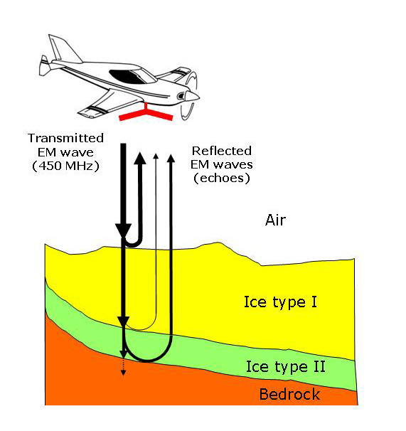 Figure 1. The measurement principle (only for major echoes here). The wave emitted by the radar is partly reflected by every layer with a sudden change in its material properties (interfaces). This occurs between air and ice, between ice and bedrock and, potentially, between two ice types.
The advantage of using an array of antennas
To achieve such precision, the EPFL scientists had to deploy several strategies. “A traditional antenna tends to scatter the rays when it emits or receives waves”, explains Professor Mosig. The LEMA team therefore set up an array of eight antennas in a rectangular device that can obtain a trace with precision from only a few dozen meters with the best possible orientation. “Each of these antennas emits a part of the wave and when these various emissions meet, some waves are cancelled while others are reinforced. Through some complex calculations we can then orientate our final wave and make it as precise as possible.” The professor adds: “A few hundred watts – the power of around a hundred mobile phones (c. 1-2 W each) - is enough to penetrate these layers.”
The preliminary results of the expedition conducted in Antarctica will be revealed over the summer at the 11th International Symposium on Antarctic Earth Sciences in Edinburgh in Scotland. They constitute already a major advance for research on Earth. Professor of Geology at EPFL Aurèle Parriaux welcomes the advance. “We are always interested in tools that enable us to analyze the geophysical properties of different environments as well as their structure. I consider this to be a highly promising project”.
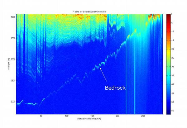
Figure 2. A typical example of detection in Greenland of the bedrock profile at 3 km below the ice over a 300 km distance. The gradual color shift shows the wave fading out. The echo created by the bedrock is clearly visible.