Connected urban planners can better serve city residents
. © Stéphanie Hasler")
Singapore Marine Bay (photo montage). © Stéphanie Hasler
By comparing the cities of Geneva and Singapore, an EPFL thesis found that urban planners can reap multiple benefits by better leveraging digital technology. That will not only make their processes more efficient, but also let them incorporate residents’ ideas into initiatives for making their cities more sustainable.
Today’s urbanites are ultra-connected and want to make their voices heard on key issues affecting their cities and neighborhoods. Digital platforms are the most convenient and efficient way to do this – but most cities lack the requisite technological capabilities. That means residents’ input is seldom incorporated into planning decisions. At least that’s the main finding of an architecture thesis carried out at EPFL and defended on 28 November. The study compared Geneva with Singapore, an Asian metropolis recognized as the world’s preeminent smart city.
“We feel we’re at a pivotal moment. People are adopting new lifestyles – new ways of living, working and getting around. But the tools used for urban planning haven’t changed. Geneva’s district maps date back to 1929! So there’s a gap between the way city residents live today and the methods used to design their neighborhoods. That’s what made me want to investigate this topic further,” says Stéphanie Hasler, an architecture researcher at EPFL’s Urban and Regional Planning Community (CEAT), a research center headed by Jérôme Chenal and Marc Soutter.
Dozens of tools at hand
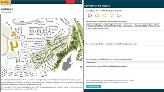
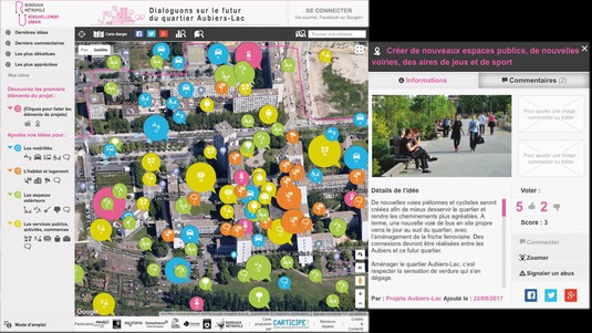
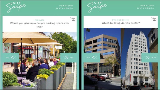
This gap exists despite the dozens of tools urban planners have at their disposal for collecting data on how residents use city services: social media, crowdsourcing platforms and mobile apps, to name just a few (see photos galery). Hasler visited Singapore and saw that its city officials use such tools on a daily basis because city residents willingly share their personal data and ideas with local authorities. A few years ago, the city set up a website where residents can view plans for current and future projects and give their opinions. The website encourages dialogue and prevents residents from having to make a trip to the local planning office.
Changing city
So what tools does Geneva have? “Things are changing and I wanted my thesis to make a positive contribution to the city’s development,” says Hasler. She found that Geneva currently uses data only for broader management purposes, such as to reduce traffic congestion or improve energy efficiency. And efforts to solicit residents’ opinions relate primarily to getting feedback on existing projects rather than spawning new ideas. However, Hasler stresses that involving residents in the planning phases is essential for making cities more sustainable, particularly in the areas of transportation and reducing greenhouse gas emissions. She also points out a dichotomy unique to Switzerland: “This country has a highly developed sense of democracy as well as advanced technology, but the two are not always combined,” she says.
List of digital platforms
So how can city officials improve things? Hasler’s thesis includes a list of digital platforms that they could use to better listen to and incorporate residents’ ideas. She came up with the list after testing around 50 such platforms worldwide, which she grouped by type of urban project they are meant to address.
Hasler prefers to talk about “responsive cities” rather than “smart cities,” as the former implies putting residents’ needs first. “Urban planners have to serve as coordinators between politicians, experts and residents. Digital technology is essential to doing this effectively, because it helps incorporate the interests of all stakeholders in decision-making,” she says. However, Hasler sensed resistance to the concept of connected urban planning among some of the Geneva planners she interviewed in her research. “Staff training or continuing education programs will be necessary,” she adds.
Combining the 15 district maps
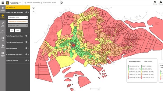
In addition to efforts to more fully involve city residents, Hasler states that Geneva city officials could also work on streamlining their processes and combining the 15 district maps into a single application that all city staff could use. That would help prevent people from working in silos and eliminate discrepancies among the maps. Singapore has been using such an application since 2016, which can also display real-time information on the types of transportation that city residents are using, for example.
This thesis research was carried out at EPFL’s Urban and Regional Planning Community (CEAT) in association with ETH Zurich’s Future Cities Lab in Singapore.

Stéphanie Hasler, “From smart to responsive: the challenges of urban planning in the digital age,” thesis supervised by Jérôme Chenal and Marc Soutter, 28 November 2018.